One of the most popular scenic areas in Ireland,
the Ring of Kerry offers a variety of scenery including, mountains,
lakes, coastal areas, bogs and colourful villages.
By car it is best to do the journey clockwise
as coach tours must go anti-clockwise. In this way you can avoid
trailing behind a convoy of coaches. Take care though, the roads
are narrow and it can be quite daunting to meet a large coach
coming round a bend.
Start at Killarney and take the N71
for Kenmare. You will pass Muckross House. Stop and take in
the view of the Lakes of Killarney from Ladies View. At Molls
Gap go left. Continue to Kenmare through some very dramatic
scenery. Kenmare is a lovely vibrant town, a good place to stop
for lunch or see some of Kenmare's famous lace at The Heritage
Centre in the Square.
From Kenmare take the N70 to Sneem.
A stop is essential in the small colourful village of Sneem.
See the different pieces of sculpture on the village greens,
of which there are two, separated by a small bridge. Follow
the road towards Caherdaniel. Take a small detour to see Staigue
Fort, a 2000 year old ring fort, one of the best preserved in
the country. A few kilometres further on is Derrynane House,
the 17th century home of Daniel O'Connell known as The Liberator.
Climb up towards Coomakista and stop in the car park to admire
the view. Heading down towards Waterville on a clear day, you
will just catch your first glimpse of the pointed tip of Skellig
Michael, the site of an ancient monastery.
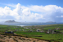
Waterville, the next cluster of habitation,
is a short strip of hotels and shops overlooking the sea. The
statue of Charlie Chaplin gets its fair share of attention.
Charlie Chaplin put Waterville on the map when he spent several
holidays here in the 60s. From Waterville the road heads towards
Caherciveen. A few kilometres outside Waterville, just after
the church, a turn to the left heads down to Ballinskelligs
Bay, a scenic route linking Waterville with Valentia Island.
Portmagee is the departure point for boats to the Skelligs Islands,
two small rocky islands that stand like miniature cathedrals
out in the ocean. The Skellig Experience in the Skellig Heritage
Centre in Portmagee tells of the history and archaeology of
the early Christian monastery, the monks, the sea birds and
the lighthouses.
Head back towards Caherciveen. Just
outside the town on the left there is a monument to St. Brendan
the Navigator who, it is said, discovered America before Christopher
Columbus. Follow the road towards Kells. At Kells stop at the
Kells Sheep Centre and see Brendan Ferris put his prize-winning
sheepdogs through their paces. The demonstrations are only on
in the mornings. It is a real tourist pulling exercise but well
worth the stop. When you get to Glenbeigh, take another detour
left down to Rossbeigh Beach.
From Glenbeigh, head towards Killorglin.
On the way you will pass The Kerry Bog Village Museum just beside
the Red Fox pub. This museum shows life in a turf cutters house
during the 19 century. Head onwards towards Killorglin, a pleasant
town overlooking the River Laune and host to the annual Puck
Fair held every year in mid-August
Return to Killarney and relax with a
pint or a cup of tea and a scone in one of the many pubs or
coffee shops to be found in Killarney.
Start at Tralee and take the N86 to Dingle.
This is only a distance of thirty miles (48 kilometres) but
it will take quite a while to negotiate the roads. If you have
children they might appreciate a visit to Aquadome in Tralee.
Continue to Blennerville on the outskirts of Tralee and take
time out to visit the Blennerville Windmille, a restored windmill
originally built in 1800. Continue to Camp and take the road
to the Connor Pass. If you don't like narrow winding mountain
roads, (456 metres), take the alternative route via Annascaul.
The road through the Connor Pass affords breathtaking views
of Dingle Harbour and Mount Brandon.
Dingle was the chief harbour in Kerry in Medieval
times. It still has a significant commercial fishing fleet.
As a result it is a good place to stop for a seafood lunch in
any of the quayside pubs. It is also the embarcation point for
visits to Fungie, the pet Dolphin who took up residence in Dingle
Bay 1983. Boats leave from the harbour at various times during
the day depending on demand. The trip will last an hour to an
hour and a half. Fungie invariably provides a show of jumping,
and swimming for the appreciation of the audience.
Leaving Dingle, take a left over the bridge
at Milltown and continue straight on, taking the sign for the
Slea Head Drive. From here travel to Ventry. As you drive in
to Ventry you will see below you the beach reputed in legend
to be the beach where the Fianna, under the leadership of Fionn
Mac Cumhaill, defeated the King of the world, Daire Doon and
his vassals.
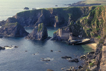
Six kilometres (less than four miles) from
Ventry, the road meets the coast and from here the scenery is
breathtaking provided there is no mist. Along this coastal road
you will find many prehistoric archaeological remains. Look
out to your left for the promontory fort of Dunbeg , which dates
from the Iron Age. Just after Dunbeg on the right are clusters
of stone beehive huts dating, it is thought, from early Christian
times, and once used by pilgrims visiting the area. Most of
these are on private land and a small fee is asked for by the
landowners, if you wish to see them at close quarters. Coming
round the Slea Head promontory the Blasket Islands will come
into view. Boat trips to the Great Blasket are available from
Dunquinn Harbour, which is a little further on.
The road continues around Dunmore Head towards
Dunquin. In the sound below two ships of the Spanish Armada
went aground in 1588. They were the Santa Maria de la Rosa and
the San Juan. The Great Blasket Centre in Dunquin celebrates
the rich life of the islanders. Only one of the Blasket islands
was occupied up to 1953 but the small community still managed
to produce three fine writers; Maurice O'Sullivan, Peig Sayers,
Tomás O'Criomhthain. Further on is the Louis Mulcahy
Pottery workshop where you can see the potters at work and see
their results in the two-floored shop. Continue onwards towards
Ballyferriter, which has a small heritage museum.
Try one of the small pubs and you are likely
to hear Irish being sopken as this a Gaeltacht area where Irish
is the first tongue. This area plays host to many Irish secondary
school students during the summer months when they come to boost
their knowledge of the Irish language. This explains the presence
of hoards of youngsters walking or cycling on the roads.
Leaving Ballyferriter continue towards Dingle
again or take the sign for Gallarus Oratory, which is a perfect
example of an 8th century dry stone building. Return to the
main Dingle Road or follow the road to Brandon Creek. An ideal
area for stretching the legs, it was from Brandon creek that
St. Brendan reputedly set off on his voyage to the Islands of
Paradise in the 5th century. A modern day navigator, Tim Severin,
proved that it was possible for St. Brendan to have reached
America many years before Christopher Columbus. Return to Dingle
and unwind.
This route starts at Ennis. Take the R476
from Ennis to Corrofin. A few kilometres after Corrofin where
the roads from Ballyvaughan, Kilfenora and Corrofin meet, you
will come to the ruins of a 16th century tower house called
Leameneagh Castle on your left. Leameneagh Castle was the home
of the legendary Máira Rua who outlived three husbands.
According to stories her husband, Conor O'Brien died fighting
the Cromwellians who captured and garrisoned the castle. Because
her lands and property were in danger she sought an officer
of the Cromwellian army as a husband and was successful, thus
saving the property for her son.
Take the road left and pass by Leameneagh
Castle and up the hill towards Ballyvaughan. You will notice
grey limestone rocks beginning to be more prevalent on either
side of you. When you see these you will know that you are in
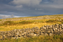
The Burren. The word 'Burren' means 'a stony place'. The Burren
is a plateau of carboniferous limestone, which results in a
sort of lunar landscape, which covers about 100square miles/250
square kilometres of County Clare. It is renowned for its variety
of flowers and plants. Here Mediterranean and Arctic plants
co-exist side by side due to some strange ecological quirk.
Some kilometres along this route to Ballyvaughan
you will see on your right, standing in the centre of the limestone
pavements the Pooulnabrone Dolmen, a portal tomb dating from
around 3800 BC. The dolmen is on private land and sometimes
a donation is asked for by the owner of the land. Just a little
but further on, again on the right hand side is the Gleninsheen
Wedge Tomb, dating from about 3000 BC. In this area was found
the Gleninsheen Collar, a gold gorget dating from the Bronze
Age. It can be seen in the National Museum in Dublin.
Ballyvaughan is a busy little village. At
the monument in the centre veer left towards the quay. A good
stop for lunch is Monk's Seafood Bar, great for fresh fish or
thick creamy seafood chowder on cold days. A small detour along
the N67 heading towards Galway will bring you to the Whitethorn
Visitor Centre. The centre shows an interesting audio-visual
display explaining the geology, flora and fauna of the Burren.
Head west again by the quay on the N477 coast
road towards Black Head, an area of breathtaking scenery. Stop
at one of the many pull-ins and hunt for exotic plants, gentians,
orchids or mountain avens. It is always useful when visiting
the Burren to have a book of Burren plants and flowers. I would
recommend 'Wild Plants of the Burren and the Aran Islands' by
Charles Nelson.
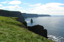
Follow the road to Lisdoonvarna and take the
R478 to the Cliffs of Moher. The cliffs are one of Ireland's
most popular destinations. Eight kilometres/five miles of sandstone
cliff, rising majestically out of the sea, to a height of over
200 metres/650 feet. There is an excellent visitor centre with
toilets, a shop and tourist information. The Cliffs can be very
crowded in high season but if you take the route 'less travelled'
to the left rather than following the crowds to the right, up
to the tower, you will have peace from the throngs. It can be
very windy on the cliffs and care is always needed, particularly
when there are children present. Binoculars are a godsend to
see more closely the many varieties of sea bird flitting from
one part of the Cliffs to another.
Leaving the Cliffs head towards Lahinch and
Ennistymon. At Ennistymon, a stop is recommended to see The
Cascades, rapids on the River Inagh, just down the lane beside
the Archway Bar. Turn left on arrival. Turn right if you're
not stopping. Head towards Inagh and back to Ennis and a well
earned Irish coffee in the comfortable old-world elegance of
the Old Ground Hotel on Station Road.
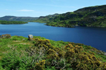
Start at Galway and take the N59 towards Oughterard,
passing Lough Corrib on the way. Lough Corrib is the largest
lake in the Republic, over 48 kilometres/30 miles long and covering
an area of 200 square kilometres/125 square miles. Lough Corrib
is an angling paradise.
The Connemara Marble Factory is in Moycullen.
You will see it on your left. They have some nice pieces of
jewellery made from the marble. Information on the formation
and cutting of marble is also provided if you ask. Continue
on towards Oughterard the 'Gateway to Connemara'.
Boat trips on Lough Corrib are available from
Corrib Cruises. Once you leave Oughterard the scenery changes
and becomes more desolate with many lakes, bogland and mountains.
On reaching Maam Cross turn right into Joyce
Country and the Maam Valley, an area of wild and desolate scenery.
Continue on to Leenane. A stop at Leenane is worth it for a
short walk to Aasleagh Waterfall. It is possible to take the
car but it's nicer on foot. If the rhododendrons are out (May/June)
the sight is wonderful. Leenane was the setting for 'The Field',
a film based on a John B. Keane play and shot in 1989. The name
of Leenane was further put on the literary map with the success
of Martin McDonagh's play, 'The Beauty Queen of Leenane'.
There is an alternative and more scenic route,
which does not include Leenane. Instead of turning right at
Maam Cross, continue on to Recess and just outside Recess turn
right and cross the Inagh Valley. It is very similar to the
Maam Valley but the presence of lakes just makes it more picturesque.
It is possible to take a little detour to Leenane before continuing
on to Kylemore.
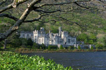
Continue on the N59 to Kylemore Abbey. Kylemore
Abbey is an exclusive boarding school but it is also a very
popular tourist centre. The main house is open to the public
as is the craft shop, restaurant and coffee shop. There is also
a walled garden and a beautifully restored church. The Visitor
Centre has a short audio-visual film on the history of the house
and the Benedictine nuns who now run the whole shebang.
From Kylemore continue on to Letterfrack.
Visit the Connemara National Park in Letterfrack. A good audio-visual
film explains the flora and fauna and geology of the area. Nature
trails are laid out with nice gentle walks. If you are more
energetic you can take one of the organised walks, which take
place in July and August, Mondays, Wednesdays and Fridays, leaving
at 10.30. They last two/three hours.
From Letterfrack continue on to Clifden. The
capital of Connemara, Clifden, is a cosmopolitan and bustling
town. Leave Clifden by the R341 and head towards Roundstone,
a lovely scenic drive. Just after leaving Clifden you will see
on your right the Alcock and Brown Memorial, which overlooks
the landing site of the first translantic flight made by Alcock
and Brown in 1919.
Roundstone is a pleasant, rugged little fishing
village. It is home to some very upmarket shops and equally
upmarket eating places. From Roundstone the narrow road continues
along the coast past some picturesque little fishing villages.
It is possible to continue along the coast road via Inveran
and Spiddle and Barna but that would add a huge amount of mileage
and is better travelled another day. Instead turn left as Cashel
and take the R340 to Recess and take the more main road back
to Galway.
Once back in Galway take time to explore its
little shops and streets. Start from Eyre Square, find Shop
Street, veer left into High Street and on into Quay Street into
the heart of Galway's 'Latin Quarter'.